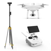
Phantom 4 RTK + D-RTK 2 Mobile Station Combo


Calculate Shipping
Express Shipping - $25.00
Fastest method
Standard Shipping - $15.00 (ETA: 5 days)
(flat rate per order)
Product Description
The complete kit comes with the D-RTK 2 Mobile station, and Phantom 4 RTK designed explicitly for professional solutions for Surveyors, Civil Engineers, Drone Service Providers, Construction Site Managers and BIM/VDC Managers.
FEATURES
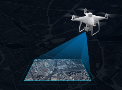 DJI has rethought its drone technology from the ground-up, revolutionising its systems to achieve a new standard for drone accuracy – resulting in the creation of the Phantom 4 RTK. The system was designed by looking at the requirements from the drone mapping and surveying market and building what they wished for – a small drone solution with a high-resolution camera and the ability to capture centimeter-accurate RTK data.
REAL-TIME KINEMATICS BASICS
Real-time Kinematic or RTK is an advanced satellite positioning system utilizing ground station as secondary position reference to delivering highly precise centimetre-level accuracy data. Combine and contrast position data captured from a virtual or physical base station, the Phantom 4 RTK’s camera would geotag the centimetre-level precision data into the image. Radial and tangential lens distortions were measured for every Phantom 4 RTK’s camera to have its unique distortion parameters and write these distortion parameters into the image for post-process calibration.
CENTIMETRE – LEVEL POSITIONING SYSTEM
The integrated RTK module provides accurate positioning data even with no GCPs. Stores the satellite observation data for PPK (Post-Process Kinematic) position post-process. Compatible with the D-RTK 2 Mobile Station, NTRIP (Network Transport of RTCMv3 via Internet Protocol) and third-party RTK stations (Only PPK is available when the ground station is without the NTRIP service.)
INTEGRATED RTK MODULE
 A new RTK module is integrated directly into the Phantom 4 RTK, providing real-time, centimeter-level positioning data for improved absolute accuracy on image metadata. Sitting just beneath the RTK receiver is a redundant GNSS module, installed to maintain flight stability in the signal-poor regions such as dense cities. Combining both GNSS and RTK modules, the Phantom 4 RTK can optimise flight safety while ensuring the most precise data captured for technical surveying, mapping, and inspection workflows. Ocusync 2.0 Enjoy stable and reliable HD live video transmission at distances of up to 4.3 miles*, the Phantom 4 RTK is great for mapping larger scale sites. Note: Unobstructed, free of interference, when FCC compliant. Maximum flight range specification is a proxy for radio link strength and resilience. Always fly your drone within visual line of sight unless otherwise permitted.
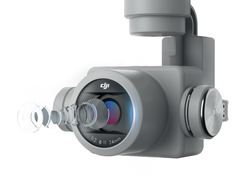
PRECISE IMAGING SYSTEM
- 1-inch CMOS sensor, 20M effective pixels, 2.7 cm GSD (Ground Sample Distance) at 100 m flight altitude.
- Radial and tangential lens distortions measured for post-processing image calibration.
- The camera is synchronized with the RTK module, delivers millisecond-level imaging deviation.
- Phantom 4 RTK’s camera would capture and store the phase compensation data for the post-processing position calibration
- The mechanical shutter on Phantom 4 RTK’s camera eliminates rolling shutter distortions which can occur when flying at high speed, allows high-precision shots to capture without the wobble distortion.
Timesync
To take full advantage of the Phantom 4 RTK’s positioning modules, the new TimeSync system was created to align the flight controller, camera and RTK module continually. Additionally, TimeSync ensures each photo uses the most accurate metadata and fixes the positioning data to the centre of the CMOS – optimizing the results from the photogrammetric methods and letting the image achieve centimetre-level positioning data.
Distortion Correction
Enable distortion correction would calibrate the optical distortion caused by the camera lens, real-time calibrated images would be captured and stored in Micro-SD card. Disable the distortion correction would have Phantom 4 RTK’s camera capture the unedited image with the fisheye effect. The lens distortion parameters were all pre-measured. These parameters would all be saved in “DewarpData” under the XMP field for every image taken. You can also input these parameters manually to calibrate the image distortion with the third-party software. (The location of the principal point should first meet the third-party software. (The position of the primary point should first meet the third-party software’s requirements to proceed. Match the imager origin point of the distortion parameter given by XMP with the principal point.) Distortion calibration using post-processing software would have better accuracy compared to the built-in distortion correction feature in the GS RTK app.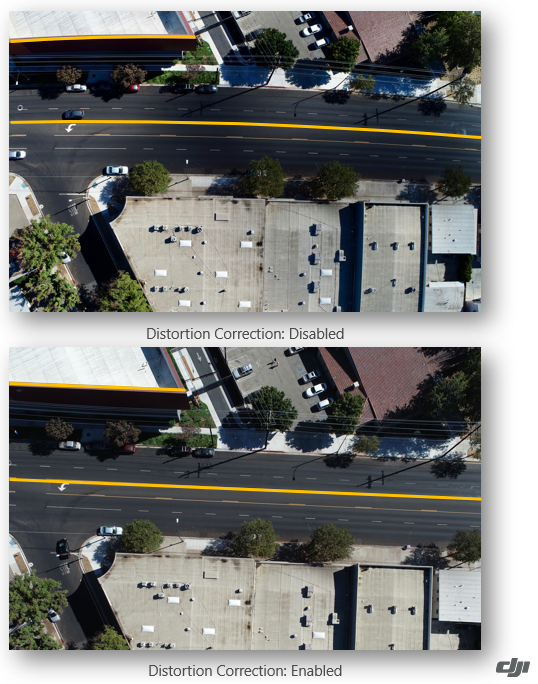
D-RTK 2 HIGH-ACCURACY MOBILE STATION
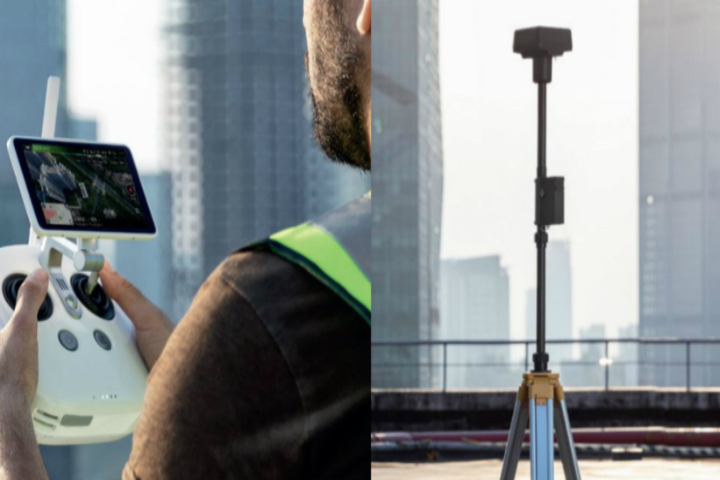
- Supports four satellite navigation systems: GPS, GLONASS, BeiDou, and Galileo
- Supports both Ocusync 2.0 and 4G connectivity
- Supported for multiple DJI aircraft models’
- Still Detection: The RTK station should always maintain still during the operation. However, if the station has been moved or tilted accidentally, its Still Detection feature would automatically detect its changed stationary state and report the captured data as the unreliable result
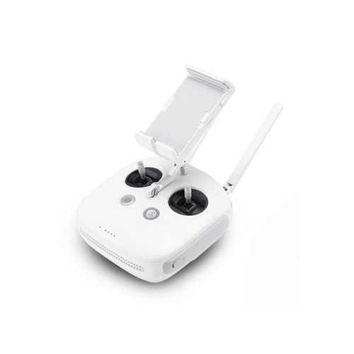
REMOTE CONTROLLER
- Built-in with a 5.5″, 1000 cd/m² high-brightness LCD display
- Interchangeable battery and antennas design
- Phantom 4 RTK’s remote controller has a built-in secondary battery to ensure the system would continuously operate while hot swapping external batteries
- Built-in DJI GS RTK app
- Latest OcuSync transmission system, transmission range up to 4.3 miles (unobstructed, free of interference)
- The remote controller’s Multi-Aircraft Control Mode can be used to coordinate the operation of up to five aircraft at the same time, enabling pilots to work efficiently
- Supports 4G, Wi-Fi, and OcuSync 2.0 connectivity
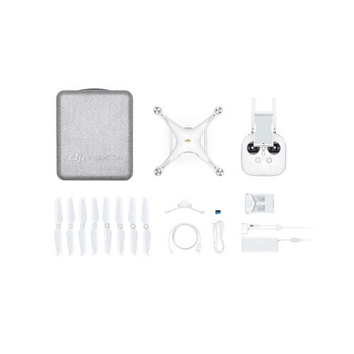
DJI Phantom 4 RTK aircraft body
– Remote controller with a built-in screen
– 4 x propeller pairs
– 2 x flight batteries
– 1 x AC power cable
– 1 x AC power adapter
– 1 x WB37 battery for the remote controller
– 1 x WCH2 Intelligent 2 bay WB37 battery charging hub
– 1 x Intelligent 4 bay flight battery charging hub
– 1 x Gimbal clamp
– 1 x 16GB MicroSD memory card
– 1 x Micro USB cable
– 1 x USB-C cable
– 1 x USB-C OTG cable
– 1 x carry case
– 1 x GNSS base station
– 1 x tripod for GNSS base station
(18384)
| SKU | 18384 |
| Brand | DJI |
Be The First To Review This Product!
Help other UAV ME users shop smarter by writing reviews for products you have purchased.

